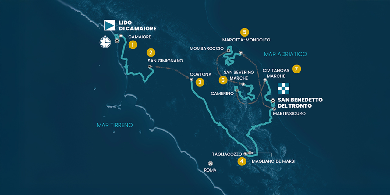
10/03/2025
profile
map
technical info
This perfectly flat route consists of two virtually straight sections along the seafronts of Camaiore and Viareggio, with only a few connecting curves and a turnaround point. Riders will make a U-turn at kilometer 5.4 in Viareggio, where the intermediate time check will be taken. They then head back along a straight section to Lido di Camaiore, where an S-turn introduces the final kilometer.
Last kilometers
The last 3 kilometers are flat, heading north on an uninterrupted, straight stretch. The finish line is on asphalt, with a road width of 7 meters.
11/03/2025
profile
map
technical info
A rolling and varied stage, particularly in the second half. Starting in Camaiore, the route climbs through Montemagno before reaching Pisa and continuing to the Livorno province. The course then leaves the coast near Cecina, heading inland towards Canneto. After a long stretch, mostly downhill, the riders enter a final circuit of approximately 20 km, which will be completed once.
Last kilometers
The final circuit is almost entirely urban, featuring several turns. The last kilometers are predominantly straight, on asphalt, with a road width of 8 meters.
12/03/2025
profile
map
technical info
A very long stage, fairly undulating in the first part. Starting in Follonica, the route passes through the northern part of the Grosseto province, skirting Monte Amiata and crossing the Siena region by climbing the Passo del Lume Spento and La Foce before reaching the towns of Montalcino and Chiusi. The terrain then becomes more forgiving, crossing the Trasimeno plain on mostly straight roads, occasionally with narrow sections. After Foligno, the final climb begins, leading to the Valico di Colfiorito, located at about 4 km to go.
Last kilometers
The final kilometers unfold on a sharp ascent. The toughest section is at the beginning, with gradients exceeding 10%, followed by a slightly uphill false-flat leading to the summit. A short descent follows, and after passing through the town of Colfiorito, a brief climb leads to the finish.
13/03/2025
profile
map
technical info
A very undulating stage culminating in an entirely flat finish. The route includes several Apennine climbs of considerable length (around 15 km each) but not particularly steep, before descending into the Fucino plain. Upon reaching Trasacco, the riders will complete a 14 km circuit, repeated twice.
Last kilometers
The final kilometers take place on a completely flat circuit, repeated twice. The circuit consists of perfectly straight roads connected by right-angle turns. The section through the town center is slightly more technical. The finish is on asphalt, with a road width of 8 meters.
14/03/2025
profile
map
technical info
Another highly undulating stage dotted with climbs of varying difficulty, with at least nine categorized ascents, some of which are designated as KOMs. Starting in Ascoli Piceno, the route crosses Croce di Casale, Amandola, Sarnano, and Tolentino, heading steadily north. It skirts the slopes of Monte San Vicino before entering the challenging final section. After Castelleone di Suasa, the riders face the climbs of Monte Santa Croce and Monte della Serra, featuring long, steep sections. The descent from the second climb leads directly into the center of Pergola, culminating at the finish line.
Last kilometers
The final kilometers are partially downhill and flatten out as the route enters the city. In the very last kilometer, the road begins to rise slightly. The finishing straight is 7 meters wide, on asphalt, with a gentle uphill gradient.
15/03/2025
profile
map
technical info
This is the toughest stage of the Tirreno-Adriatico, featuring a challenging summit finish. The route winds through the rolling hills of the Marche region, with constant ups and downs in the first part, interrupted by key climbs like Crispiero and the Valico delle Arette (after tackling the Santuario di Macereto). In the final section, the race passes through Ussita, Visso, and Castelsantangelo sul Nera, before heading into the decisive final ascent.
Last kilometers
The final kilometers consist of the ascent to Frontignano, a climb of about 8 km with long stretches above 10%, especially in the first part. The road is wide and features a series of tight hairpins. As the riders approach the last kilometer, the gradient slightly eases. The final stretch is a 6-meter-wide straight on asphalt.
16/03/2025
profile
map
technical info
Relatively flat stage in the first part and completely flat for the last 80 km. It starts along the Adriatic coast before entering the Aso valley from Pedaso. There’s a short climb to Santa Maria della Fede, followed by the final, relatively easy ascent to Ripatransone. A long downhill section follows, leading the athletes down to Grottammare, before entering a 15 km circuit to be repeated 5 times. The circuit features mostly straight, wide, and asphalted roads.
Last kilometers
The final 3 km are on wide, mostly straight roads, with some gentle bends on medium-width roads in the first part. The last double bend occurs about 1 km from the finish. The road is 8 meters wide, with an asphalt surface.
Lido di Camaiore – Lido di Camaiore TUDOR ITT
profile
map
technical info
This perfectly flat route consists of two virtually straight sections along the seafronts of Camaiore and Viareggio, with only a few connecting curves and a turnaround point. Riders will make a U-turn at kilometer 5.4 in Viareggio, where the intermediate time check will be taken. They then head back along a straight section to Lido di Camaiore, where an S-turn introduces the final kilometer.
Last kilometers
The last 3 kilometers are flat, heading north on an uninterrupted, straight stretch. The finish line is on asphalt, with a road width of 7 meters.
Camaiore – Follonica
profile
map
technical info
A rolling and varied stage, particularly in the second half. Starting in Camaiore, the route climbs through Montemagno before reaching Pisa and continuing to the Livorno province. The course then leaves the coast near Cecina, heading inland towards Canneto. After a long stretch, mostly downhill, the riders enter a final circuit of approximately 20 km, which will be completed once.
Last kilometers
The final circuit is almost entirely urban, featuring several turns. The last kilometers are predominantly straight, on asphalt, with a road width of 8 meters.
Follonica – Colfiorito (Foligno)
profile
map
technical info
A very long stage, fairly undulating in the first part. Starting in Follonica, the route passes through the northern part of the Grosseto province, skirting Monte Amiata and crossing the Siena region by climbing the Passo del Lume Spento and La Foce before reaching the towns of Montalcino and Chiusi. The terrain then becomes more forgiving, crossing the Trasimeno plain on mostly straight roads, occasionally with narrow sections. After Foligno, the final climb begins, leading to the Valico di Colfiorito, located at about 4 km to go.
Last kilometers
The final kilometers unfold on a sharp ascent. The toughest section is at the beginning, with gradients exceeding 10%, followed by a slightly uphill false-flat leading to the summit. A short descent follows, and after passing through the town of Colfiorito, a brief climb leads to the finish.
Norcia – Trasacco
profile
map
technical info
A very undulating stage culminating in an entirely flat finish. The route includes several Apennine climbs of considerable length (around 15 km each) but not particularly steep, before descending into the Fucino plain. Upon reaching Trasacco, the riders will complete a 14 km circuit, repeated twice.
Last kilometers
The final kilometers take place on a completely flat circuit, repeated twice. The circuit consists of perfectly straight roads connected by right-angle turns. The section through the town center is slightly more technical. The finish is on asphalt, with a road width of 8 meters.
Ascoli Piceno – Pergola
profile
map
technical info
Another highly undulating stage dotted with climbs of varying difficulty, with at least nine categorized ascents, some of which are designated as KOMs. Starting in Ascoli Piceno, the route crosses Croce di Casale, Amandola, Sarnano, and Tolentino, heading steadily north. It skirts the slopes of Monte San Vicino before entering the challenging final section. After Castelleone di Suasa, the riders face the climbs of Monte Santa Croce and Monte della Serra, featuring long, steep sections. The descent from the second climb leads directly into the center of Pergola, culminating at the finish line.
Last kilometers
The final kilometers are partially downhill and flatten out as the route enters the city. In the very last kilometer, the road begins to rise slightly. The finishing straight is 7 meters wide, on asphalt, with a gentle uphill gradient.
Cartoceto – Frontignano
profile
map
technical info
This is the toughest stage of the Tirreno-Adriatico, featuring a challenging summit finish. The route winds through the rolling hills of the Marche region, with constant ups and downs in the first part, interrupted by key climbs like Crispiero and the Valico delle Arette (after tackling the Santuario di Macereto). In the final section, the race passes through Ussita, Visso, and Castelsantangelo sul Nera, before heading into the decisive final ascent.
Last kilometers
The final kilometers consist of the ascent to Frontignano, a climb of about 8 km with long stretches above 10%, especially in the first part. The road is wide and features a series of tight hairpins. As the riders approach the last kilometer, the gradient slightly eases. The final stretch is a 6-meter-wide straight on asphalt.
Porto Potenza Picena – San Benedetto del Tronto
profile
map
technical info
Relatively flat stage in the first part and completely flat for the last 80 km. It starts along the Adriatic coast before entering the Aso valley from Pedaso. There’s a short climb to Santa Maria della Fede, followed by the final, relatively easy ascent to Ripatransone. A long downhill section follows, leading the athletes down to Grottammare, before entering a 15 km circuit to be repeated 5 times. The circuit features mostly straight, wide, and asphalted roads.
Last kilometers
The final 3 km are on wide, mostly straight roads, with some gentle bends on medium-width roads in the first part. The last double bend occurs about 1 km from the finish. The road is 8 meters wide, with an asphalt surface.